

Sam McGrady and Steve Smedley live in Matlock, Derbyshire, and spend all their spare time (and money!) in the mountains. Back in 2019, they were both working (Sam full-time and Steve part-time), and therefore mountain trips had to be shoehorned into a finite number of days. Hence completing Alta Via 1 in 6 days!
Fortunately, they’re both fit due to an active lifestyle mainly (at that time) focused on trail running. Backpacking in a linear or circular fashion, moving from location to location on foot each day is their absolute favourite way of hiking. They are also experts, honed over many years, in traveling light – a small pack means less tired legs/feet and a more enjoyable experience overall. In 2016 they did the Tour du Mont Blanc and in 2018 the Tour de Monte Rosa. In between times, there were many short walking trips to the Canary Islands, mainland Spain, and the UK mountains. Following Covid and a significant reduction in their work commitments, in the summer of 2022 they walked the GR11 (Trans-Pyrenees route on the Spanish side of the border) in 6 weeks, and in July 2023 the Walkers’ Haute Route in Switzerland (ably aided by posts and videos from The Hiking Club). The only problem is deciding what to do next!
TRIP SUMMARY
6 hiking days
2 rest days (in Cortina)
Total distance – 143 km (89 miles)
Total ascent – 9,155m / 30,000ft
Start/finish – Lago di Braies to La Pissa (near Agordo) – all in Italy

Sam and Steve’s 6 Day itinerary hiking the Alta Via 1 in the Dolomites, as shown in our trip planning app
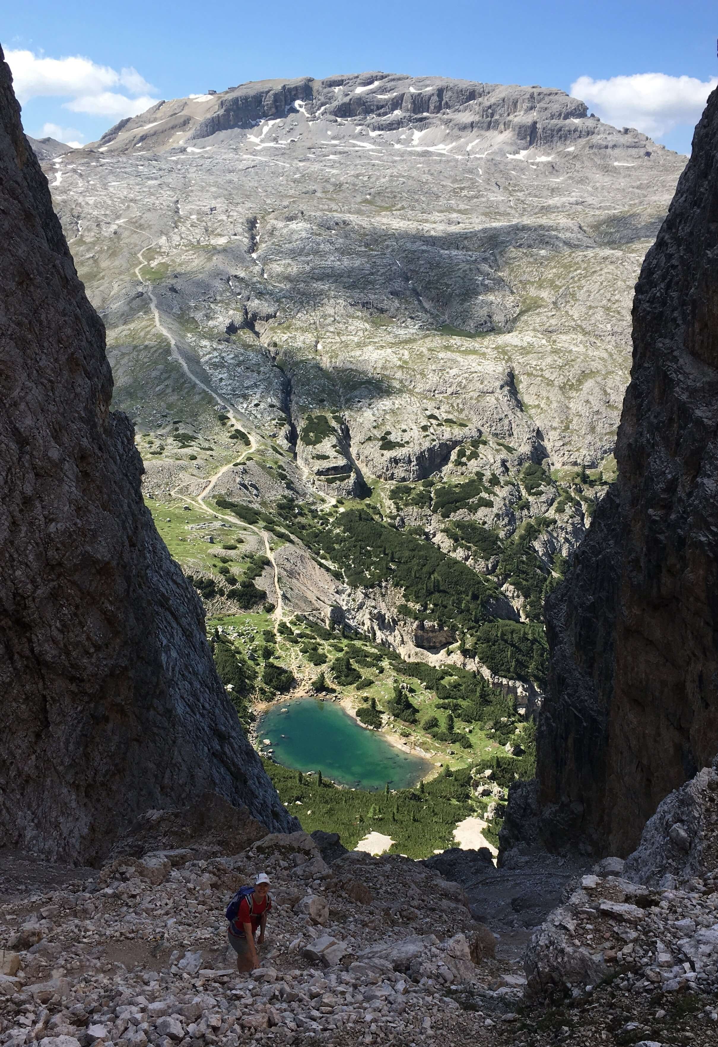
Day 1 (15 July) – Lago di Braies to Rifugio Lavarella (20km, 1550m up, 1,000m down, 7.25 hours)
Having flown to Munich and then taken a train over the Brenner Pass the previous day, we started our Alta Via 1 by taking a bus from Villabassa to Lago di Braies, which is the official start of the route. After an easy start contouring beside the lake, we then had an unrelenting ascent to Forcella Sora Forno, walking underneath Croda del Becco the whole time. We called at Rifugio Biella for coffee then continued along various jeep routes to Rifugio Sennes (which boasts the highest light aircraft airstrip in Europe). The descent to Rifugio Pederu was extremely steep and we took a break there. Finally, it was onwards and up the valley to Rifugio Lavarella. We had good weather and visibility all day until the last hour when it rained.

Day 1 - Lago di Braies
Day 2 (16 July) – Rifugio Lavarella to Cortina (26km, 1,400m up, 2,200m down, 9 hours)
After an early start from the rifugio, we headed towards Malga Fanes Grande (a farm) and saw wild horses and first world war trenches and defenses – unexpected and a bonus historic angle to the walk. We passed along a lovely valley to Passo Tadega, then headed off uphill to the most amazing ‘window’ and viewpoint, Forcella del Lago. The relentless zigzagging path which descended from there was built by Italian soldiers, and made to last! We headed down towards the Lago di Lagazuoi, then off left uphill again to Forcella Lagazuoi. We decided to give the Rifugio Lagazuoi a miss as it was extremely busy and continued to yet another pass, Forcella Col dei Bos. The route then traversed underneath the massif of Tofana de Rozes, past a weird moonscape gully to Rifugio Dibona. We left AV1 at this point and headed down, down, down to Cortina (which took a lot longer than we thought it would!).
Again, we had great weather all day, lots of sun. We stayed for 2 days in Cortina and had our first-ever Aperol spritz (before they became so popular!).

Day 2 - Rifugio Lavarella
Day 2 - Forcella del Lago

Day 2 - Passo di Tadega
Day 3 (19 July) – Cortina to Rifugio Passo Staulanza (19km, 1,200m up, 1,500m down, 8 hours)
We took a bus back up from Cortina to Cianzope, from where the route took us uphill to Cinque Torri, on to Rifugio Scoiatolli, Rifugio Averau, and Rifugio Nuvolau (all ascending). The latter is an amazing viewpoint, and we just had to stop for coffee. The next stage involved some very easy via Ferrata sporadically down to Rifugio Passo Giau. Most people were using harnesses and clips but we had decided not to carry additional gear, and in the event, it was more of a relatively easy scramble, so no problem. After crossing a road at the refuge, we headed uphill again to more mountain passes - Forcella Giau, Forcella Ambrizzola, and Forcella Col Duro. The path then took us down a very empty valley, populated only by cows, to Forcella Roan and Rifugio Citta di Fiume. We carried on traversing along scree then through woods to Rifugio Passo Staulanza – possibly the swankiest refuge we’ve ever stayed in - we had our own room with an ensuite! Once again, the weather was kind and we did not get wet.

Day 3 - Cinque Torri
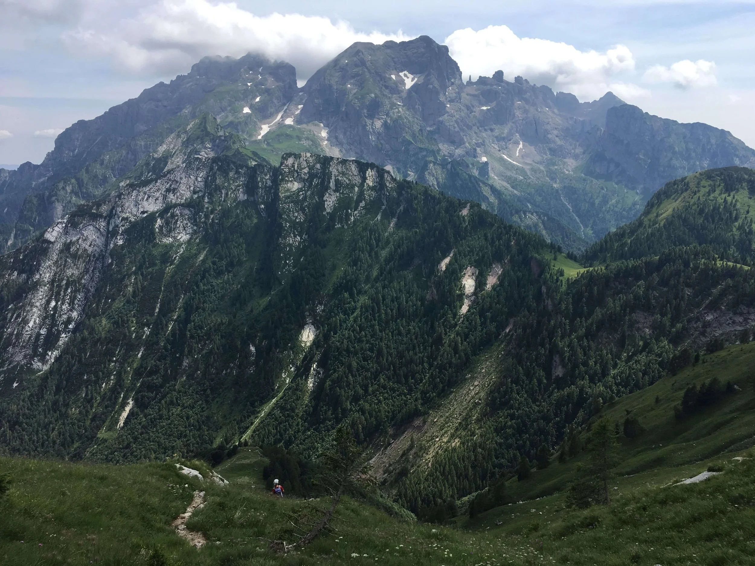
Day 4 (20 July) – Rifugio Passo Staulanza to Mareson (20km, 1,195m up, 1,500m down, 8 hours)
At this point, we took an AV1 variant, around the Giro di Pelmo. This is a spectacular route that circles Pelmo and includes a decent climb on very friable rocky paths with cables to assist. At the top, Forcella Val d’Arcia, it truly felt like we were in high mountains. The way back down was no less tricky and involved a certain amount of scree running (not for the faint-hearted but fast!). We stopped at Staulanza for coffee and strudel and to collect one of our rucksacks we’d left there for the day, then headed slightly off the AV1 down to Mareson where we had accommodation booked for the night (a hotel). To try to save time, we made a bad decision to take a small (black dots on the map) path which was clearly hardly used; we regretted it as we had to clamber under and over what felt at the time like hundreds of fallen trees which were blocking the path to eventually reach Mareson. We were still picking pine needles out of our hair days later! Fortunately, the hotel was lovely and quiet and we had our best AV1 breakfast there – which included apple strudel!

Day 4 - Giro di Pelmo
Day 5 (21 July) – Maresol to Rifugio Carestiato (25km, 2,000m up, 1,500M down, 8.5 hours)
After an additional hour or so’s hiking back up to the AV1 route, we headed uphill on a very busy path to Rifugio Coldai, then Lago Coldai. We were hiking underneath the amazing Civetta for most of the day. The reason for the huge number of people on the path soon became apparent – a mountain running race (Transcivetta – more than 1200 participants, 24km) was taking place that day and we had joined the scores of spectators climbing up to the route to cheer runners on. It was certainly a nice distraction from our ascent! We continued to Forcella col Rean, dodging runners the whole time. We decided to miss out on Rifugio Tissi as there were so many runners and walkers there and continued down to Rifugio Vazzoler for coffee and more strudel, then up to Forcella Col dell’Orso (in very heavy rain; we got soaked). The final pass was Forcella del Camp, then we finally arrived at Rifugio Carestiato, at which point the sun was back out and we could dry off all our gear.
Day 5 - Spectators at the Transcivetta race

Day 5 - Lago Coldai
Day 6 (22 July) – Rifugio Carestiato to La Pissa/Agordo (30km, 1,500m up, 2,900m down, 11 hours)
Looking back it was a mistake to do such a long day, and we had to jog the last hour to catch a bus to take us to our accommodation in Agordo, which kind of spoilt the last day’s hiking as it became quite stressful. We ought to have stayed in Rifugio Bianchet and then had a slow walk down to Agordo the next morning. The benefits of hindsight!
The route left Carestiato to go down to Rifugio San Sebastiano, then along a very quiet road for 2km before heading off up through the forest to Forcella Dagerei. We contoured round to Forcella del Moschesin (an old barracks) and along from there to Rifugio Pramperet where we stopped briefly for coffee. We were soon back on track and climbing up to Forcella de Zita Sud, an exposed ridge walk in high mountains and pretty spectacular; this was followed by a very long descent to Rifugio Pian de Fontana where, as it was very hot and becoming hotter as we descended, we stopped for coffee, water, and fizzy pop.

Day 6: Forcella de Zita Sud
We carried on down from there and back up to exit the valley, then downhill again, this time through woods on zigzags, to Rifugio Bianchet. We got bus times (and water) here and decided to ‘jog’ down to road to catch the next bus. As is often the case, it was much further than we thought and unrelenting (to the point of being quite boring). The official end of AV1 is the bus stop at La Pissa which is where we finally boarded our bus to Agordo and that night’s accommodation.
Day 6 - Heading down to La Pissa
After a very slow and relaxed day off in Agordo, we took buses and trains to Belluno and then Verona, where we spend 3 days getting a cultural ‘fix’ including seeing La Traviata at the Arena (which was amazing and which we would highly recommend) before flying back to the UK.
Author and photography: Sam McGrady
ready to plan your alta via 1 dolomites adventure?
WHO ARE WE?
The Hiking Club empowers anyone to walk the way they want in the wild with personalised self-guided hiking experiences that are easy to find, quick to plan and simple to navigate.
We believe hiking experiences have the power to transform lives. With a growing range of personalised hikes that take into account your preferences, fitness and interests, we give you everything you need to explore the legendary trails of the world!