Confident navigation with your smartphone
We create personalised GPS trail maps to help hikers navigate their journey in the same way they would in urban areas. These maps are aligned to a hiker’s route/plan and can be used on any Android or Apple smartphone.
As the mobile trail map works offline, no cell/mobile reception is necessary to use it for navigation. This is because the mobile map uses the GPS function of your smartphone which utilises satellite position rather than cell/mobile phone towers providing internet or cell signal. This offline feature is useful in parts of the trail where there is no cell/mobile signal and especially for international travelers that choose not to buy a local sim or activate a data roaming package.

Your location and itinerary details on the map
When you arrive on the trail, your location will be highlighted on the map and your personalised hiking statistics displayed for each section and day of your itinerary, including:
distance,
elevation gain and loss, and
estimated hiking time (based on your specific speed).
Coloured Markers to highlight points of interest along the trail
Prepare for each day on the trail with key points of interest, including:
toilet,
water refill,
food/supermarkets, and
laundry locations.


Transport Options
All transport options are highlighted and show the 2023 schedules, cost, and duration for you to reroute your plan if you need to skip ahead on the trail. Included transport:
Train
Bus
Gondola / cable car.
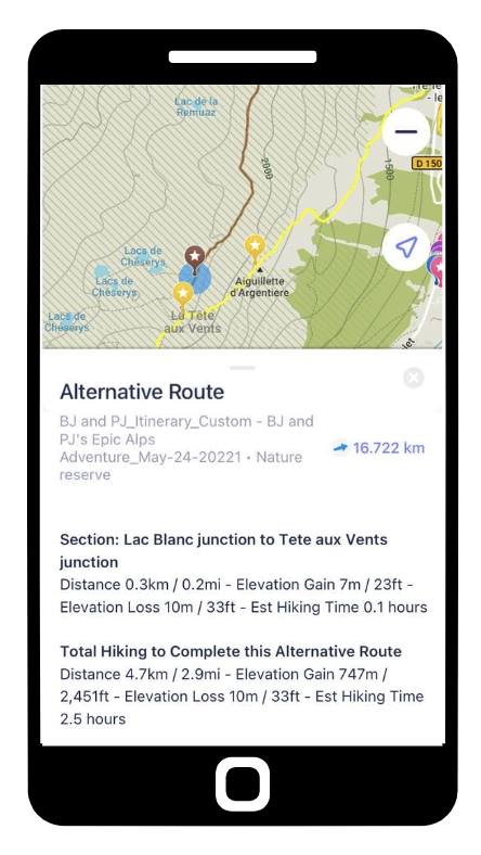
Bad Weather and alternate Routes
Change to an easier hiking route (where possible) in case of bad weather or desire to skip a difficult section (i.e ladders or swing bridge).
Know where alternate trails are and their stats so you can make an informed choice, including:
distance,
elevation gain and loss, and
estimated hiking time (based on your specific speed).