Tour des Combins | Complete Guide
Everything you need to plan, book, and self-guide this extraordinary multi-day hike through the Alps
Hike around the majestic ‘Combins Massif’ (4,314m), one of the highest in the Alps, located on the western end of the Pennine Alps. Experience both Swiss and Italian alpine culture as this journey leads you on mostly remote trails past rich historical sites, impressive engineering feats, dramatic glaciers and the famous Mont Blanc massif. Stay in spectacular mountain huts or bivouac/wild camp along this alpine trail.
KEY TRAIL STATS for “CLASSIC” ROUTE

Cabane de Mille is set on a magnificent balcony overlooking the Valais Alps in one direction and the Mont Blanc Massif in the other.
Countries: Switzerland and Italy
Number of days: Between 4 and 7 days
Distance: 97km / 60mi
Elevation gain: 6,000m / 20,000ft
Highest point: 2,863m / 9,393ft (Col des Otanes)
Season: Early: Mid-Jun to End Jun. Peak: Start Jul to End Aug. Late: Sept
Difficulty: Moderate
Traffic: Low, much less crowded than neighbouring trails i.e Tour du Mont Blanc
Start/end points: Typically Saint Bourg-Pierre, however Mauvoisin, Grand St Bernard Pass and Saint-Oyen are options.
Where is the Tour des Combins?
The Tour des Combins is a world-class multi-day hiking journey around the Combins Massif that borders Switzerland and Italy. Its peak stands at 4,314m / 14,153ft, rivalling its much more famous neighbour Mont Blanc at 4,808m / 15,774ft. The trail travels through 3 regions - Valle d’Aosta in Italy and, Val d’Entremont and Val de Bagnes in Switzerland.

The Spectaculary located FXB Panossière hut situated at the foot of the Grand Combin and the Corbassière Glacier
CLASSIC Trail Highlights
Grand Saint-Bernard Pass - the third highest road pass in Switzerland, at an elevation of 2,469 m (8,100 ft) and one of the most ancient passes through the Western Alps. Also famous for St Bernard dogs that were used in rescue operations by the Hospice, founded in 1049.
Corbassière Glacier - Get up close to this spectacular glacier that is 9.8km / 6.1mi long, average 1km / 0.6mi width and covers an area of 17.4km2 / 6.7m2.
Corbassière Footbridge - This is one of the highest galvanised steel structures in Europe, sitting 70m / 230ft above the ground. The 190m / 623ft long bridge connects Brunet and Panossière huts and allows hikers to safely cross the moraine.
Mauvoisin Dam / Lac - This hydroelectric arch dam is the highest in Europe, standing at 250m /850ft high and 520m / 1710ft long. The lake is glacier fed and is 5km / 3mi in length.


ALTERNATE TRAIL HIGHLIGHTS
Mont Rogneux - An alternate route that summits to 3,084 m / 10,118 ft, rewarding breathtaking views of Pennine Alps, including Liddes and Verbier.
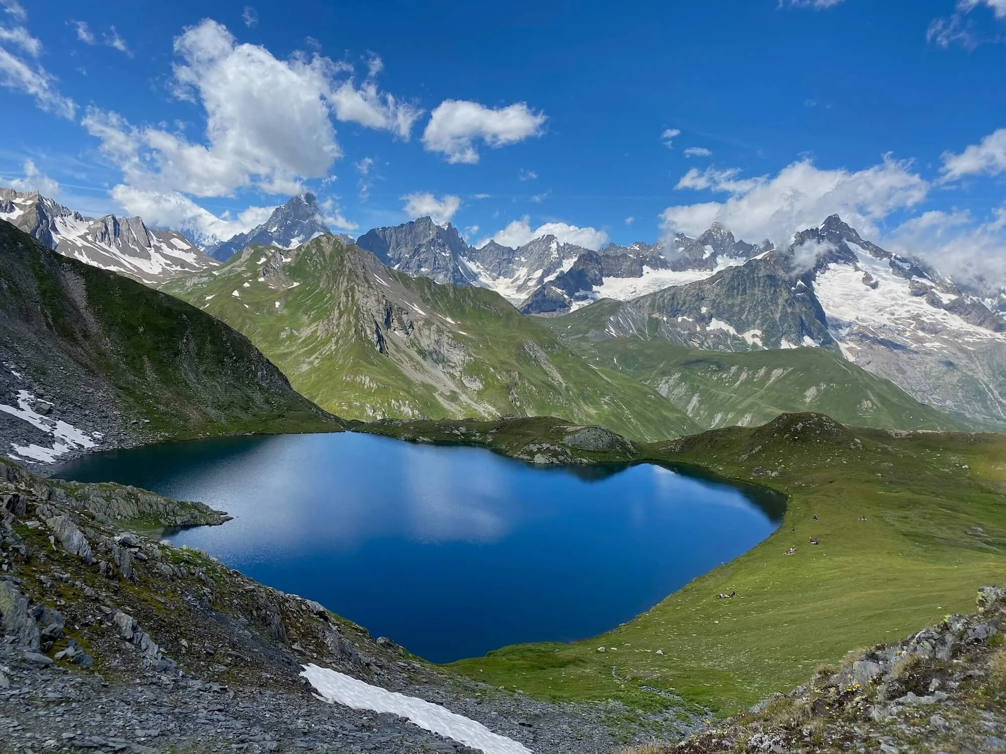
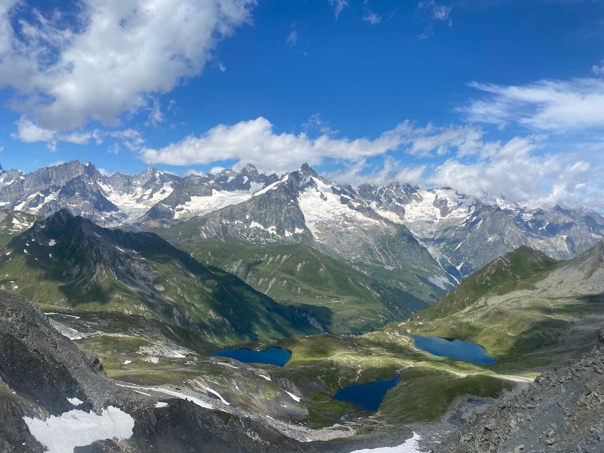
Lacs de Fenetre - Three stunning alpine lakes located at 2,500m / 8,200ft offer striking views of the Mont Blanc massif, above the Grand Saint Bernard Pass.
Border Traverse - For those looking to step up their adventure, this alternate route includes a via ferrata section as you travel along the border of Italy and Switzerland. Using ladders and cables to cross the rocky ridge. Not for the faint hearted!
WE ARE LAUNCHING tour des combins SOON!
Be the first to know when we launch our self-guided hiking packages.
WHAT TYPE OF ACCOMMODATION IS AVAILABLE ON THE tour des combins?
There are 25+ accommodation options along the Tour des Combines, ranging from mountain huts (also known as rifugios (Italian) and refuges (German) that are typically located in remote areas, to guest houses, hotels, B&Bs and campgrounds that are located in the alpine villages along the trail.


How long is the Tour des Combins?

The views of the Grand Combin and Mont Velan from the majestic Grand St. Bernard Pass
The “classic” route around the Combins Massif is 97km / 60mi, with 6,000m / 19,700ft in elevation gain and loss. Hikers are required to climb over 6 mountain passes, the highest being Col des Otanes at 2,870m / 9,416ft.
There are alternate routes that change the distance and elevation, either to take a more direct route (such as Mont Rogneux trail or Col de Lane trail), or to reach a specific highlight (such as Border Traverse trail or Fenetre de Ferret trail).
It typically takes between 4 and 7 days to complete the Tour des Combins. It depends on which route you decide to take, your hiking speed, the desired number of hiking hours per day and whether you will use transport.
when is the best time to hike Tour des Combins?

The views of the Grand Combin and Mont Velan from the majestic Grand St. Bernard Pass
The best time to hike the Tour des Combins is the start of July until mid September.
This is a high alpine trail with multiple mountain passes between 2,500 - 2,900m or 8,000 - 9,500ft and therefore most hikers prefer to wait until most of the winter/spring snow has melted on the trails, especially in the steeper, rockier areas.
During July and August, hikers are most likely to have the best trail conditions, weather and accommodation options. Typically, daylight is longer, there is less chance of rain, no/low snow on the trails, warm temperatures, alpine flowers in full bloom and lush meadows. The Alps are a paradise during these months.
Nevertheless, the Alps are no different than any other high mountain range in the world. The weather can turn at any point. There is the possibility of thunderstorms developing later in the day and don’t be surprised if you wake up to fresh snow in the higher altitudes. Although some hikers decide to hike in June and September, there are weather and accommodation limitations to consider.
How popular is the Tour des Combins?

Hotel Mauvoison - A popular weekend and day trip location connected by local bus.
Unlike the nearby Tour du Mont Blanc, the Tour des Combins is a relatively quiet trail. There are certain sections that are frequented by day-hikers and certain huts that are either accessible by car/public transport (such as Grand St. Bernard Pass and Mauvoison Dam), which result in higher traffic. Therefore, it is likely for TDC hikers to see more hikers over the weekend during July and August, both on the trail and in the mountain huts.
Where does the Tour des Combins start and end?

Grand St. Bernard Pass, one of the start/end locations along the trail
The Tour des Combins is a circumnavigation of the Combin massif, it does not summit any of the peaks on the massif. It passes through numerous towns and villages which allows hikers to select the different start/end location. The most popular start/end locations are:
Saint Bourg-Pierre, Switzerland: ~3 hours by train/bus from Geneva airport. It has a range of accommodation options, from hotels to camping. There are no stores/shops to buy food or gear, but food is available at a handful of restaurants and hotels.
Mauvoisin, Switzerland: ~3 hours by train/bus from Geneva airport, but transfers are less frequent than Saint Bourg-Pierre. There is only one hotel here and no stores/shops to buy food or gear.
Grand Saint Bernard, border of Switzerland/Italy: 3-4 hours by train/bus from Geneva airport, but transfers are less frequent than Saint Bourg-Pierre. There are a few accommodation options here that offer food.
Saint-Oyen, Italy: 4-5 hours by train/bus from Geneva or Milan airport. A handful of accommodation and food options available.
Is it possible to camp along the Tour des Combins?
Yes - it is possible to bivouac (or wild camp) or stay in campgrounds in villages along the Tour des Combins.
However, there are very strict rules put in place by the national and local governments for those that wish to bivouac. Hikers must avoid private land (high alpine farms/ski resorts) and protected nature, as well as bivouac above 2,500m / 8,200ft elevation (Italy) or beyond the forest line (Switzerland). You must also only pitch your tent between sunset and sunrise.
In terms of campgrounds, the type and quality of facilities differ, but in general there are hot showers, kiosk/cafe or restaurant and wifi. The average cost for 1 person in a small tent is 13-22 CHF or 16-18 EUR per night.
Unfortunately some villages (and key locations) don’t have campgrounds so you’ll either need to divert off the trail for a few km/mi or take advantage of low cost dormitory or hotel room options available for those nights.
The Hiking Club app will include campground and bivouac locations so you can easily incorporate them into your plan.

Camping de Champsec - basic campground with showers, shop, laundry and cooking facilities
WE ARE LAUNCHING tour des combins SOON!
Be the first to know when we launch our self-guided hiking packages.